

See Jason's account of Day Two for photos.
I awoke to a light rain after bouts of heavier rain had pattered the tent all night. When it finally let up at 6:40 a.m., I donned my Kokatat mukluks and took Jason’s water filter 175 yards back down the caribou trail we had traversed last night on our way to camp. There was a small, clear freshet trickling down the steep, rocky slope above the trail that allowed me to fill our Nalgene water bottles and 3-liter camelback water bags. After coffee and granola, I draped various rain- and sweat-soaked garments on rocks and willow shrubs in a largely futile attempt to dry things out in the cool morning breeze before it began drizzling again. We packed up the tents during a mid-morning break in the weather, hoping to reach Jason’s primary destination about 4 miles to our north and west through a presumed mountain pass by the end of the day. But it takes time to pack wet gear, and fortitude is required to don yesterday’s not-yet-dry clothing and boots in order to keep at least one set of clothes dry for the next cold night.
We broke camp at 12:35 p.m. Hefting a 70-pound pack onto the damp clothing on my back sent chills down my spine, but hauling that load up the valley would soon warm me up. We were encouraged by regular sightings of small groups of caribou cows and calves moving through the valley, often circling us within rifle range to get wind of the strange, two-legged creatures they could not quite identify by sight alone. There were probably a couple young bulls in these groups, but not the animal Jason was hoping for.
The 3-mile uphill trek from camp (at 3800 feet) to the top of the pass (at 4600 feet) required frequent rest stops to dissipate lactic acid from aching leg muscles. At such a break within ¼ mile of the top of the pass, Jason spotted an animal running along a small creek in the valley below and excitedly announced, “Wolverine!” I looked down to see the rare mammal moving systematically downstream, stopping only briefly here and there to check rock piles and other nooks for potential prey. Binoculars confirmed the creature’s identity; and Jason was able to get a couple pictures with the telephoto lens of his camera, in addition to some distant Go-Pro video. This was the first wolverine he and I had ever been privileged to see in the wild.
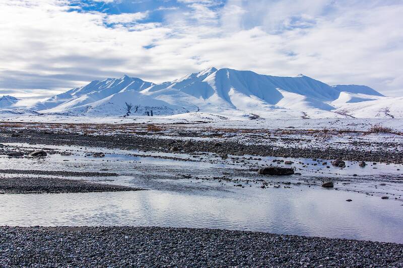
The “pass” appeared in three stages. Twice we arrived at what we thought was the top, only to discover a shelf leading to yet another steep slope upward. On the third approach, we finally reached the top of the pass, beyond which was a precipitous slope of wet rock and loose gravel that seemed far too dangerous to descend without climbing gear. The spectacular view below us included a turquoise blue lake in the foreground and the confluence of Pass Creek and Clearwater Creek in the valley below. But I immediately told Jason, “I don’t like this at all.” The prospect of carrying even a well-balanced 70-pound pack down a nearly 2:1 slope with loose footing was distressing, and I would not have considered doing it if we were not already so committed to this route.
The valley below was to be our refuge from the cold and snow later this evening. It was where Jason hoped to base camp from a vantage point to spot a bull caribou. And ultimately, Clearwater Creek less than 2 miles away was our only reasonable exit from this remote location. I could not imagine turning back and retracing our steps 9 miles with heavy packrafts we would not even use, especially if that distance would have to be covered multiple times in order to pack out a caribou. We had to get down into this river valley. And from this rocky perch above the alpine tundra, we were staring down at the only route available.
This situation called for a moment of reflection on the nature and value of topographic maps for navigation in mountainous terrain. Regardless of scale, it seems the map makers feel an obligation to show every contour line as a distinct mark separated by the tiniest of spaces if the terrain is steep. So an extreme slope (like a cliff) may be represented as a cluster of closely-spaced contour lines that gives the false impression that some slope exists, even if there is a vertical drop. Such was the case here, where the closely-spaced contour lines on the traversable uphill side of the pass were spaced no further apart than those on the scary downhill side. You can trust the topographic maps for general guidance, but not for critical navigation in the mountains.
On one edge of the pass was an area of rock and loose gravel that had occasionally been traversed by caribou, which are remarkably well adapted to traveling over almost any kind of terrain. Normally these animals travel straight up and down slopes that would make any human wish for a rope. But here, because of the steep pitch, even the caribou had created a series of switchback trails in order to maintain their footing. At 6:00 p.m. we began our descent with extreme trepidation and caution. I went first, so that if I fell, I did not tumble into Jason and cause him to fall as well. Looking downhill was dizzying and likely to induce panic, so I forced myself to concentrate on the location of my next footfall along the 6-inch-wide path. Each short step involved a gradual transfer of weight until I could be certain the rock and loose gravel there would hold. I could see places where caribou had slipped. Trying to maintain balance with a heavy pack would have been suicidal without adjustable trekking poles, which were shortened on the uphill side and lengthened on the downhill side. We traveled at a snail’s pace. After 30 minutes of painstaking descent, the slope became less severe, and I began to think we might make it without incident. I recall looking back up at the top of the pass a couple hundred yards away and thinking that nobody in their right mind would go up or down that slope if they really had a choice. For that reason, I named it “Never Pass,” because no human should ever do it again.
As it turns out, the fun was just beginning. We thought at the time that we had just survived the most dangerous part of our journey, but the next half mile was leg-wearyingly steep and littered with several massive piles of rock rubble that had tumbled off the mountains above. I was thoroughly humbled by the aftermath of water and gravity at work. The sparse alpine tundra at this high altitude was interrupted by numerous expansive minefields of coarse talus that could not be circumvented. So we picked our way through them carefully, as if carrying a 70-pound backpack down some heavily riprapped 3:1 slope of a dam built by the U.S. Army Corps of Engineers in the Lower 48, except with less uniformity. Though the risk of plunging to one’s death had abated, the risk of breaking an ankle on wobbly rocks in a highly inconvenient location had increased considerably. Trekking poles were necessary but became a liability at times, because they would get caught in crevices in the rocks and throw us off balance. We took it very slowly. I remember thinking that no one should do this without a buddy.
Finally we made it over the last pile of boulders to the headwaters of the small creek that ran through the valley. Walking was easy along the braided caribou trails in the alpine tundra alongside the stream. Soon we encountered a couple small groups of caribou at fairly close range – again, curious cows and calves only. Darkness would descend within the next couple hours, so finding a suitable campsite became our top priority. We sought a reasonably level spot with a view.
I hoped it would be easy in this vast landscape to find a level spot free of boulders to place a tent only 51 inches wide and 88 inches long. Not so. Slopes, rocks, hummocks, and depressions conspired at every turn to discourage prospective campers from trespassing on the alpine tundra. But we finally found a spot where our two Rab Latok Mountain tents and vestibules could be lashed together, side-by-side, on a slight downhill slope with a spectacular view of the river valley below. A cold, gusty wind descended upon us from back up the valley, so we hastened to erect our shelters.
Momentarily satisfied that we were set for the night, we ate our Mountain House meals while taking stock of the valley below. The experiences and observations of this day had me thinking we should be filming and writing for the National Geographic Society. Most people experience this harsh and beautiful landscape only through the portal of television from the comfort of their living room couches. We were living in it – surviving in it. And despite a few life-affirming moments of extreme exertion and legitimate fear, I felt very fortunate to be a part of all this.
Upon crawling into the tents this evening, our only concern was that they not blow away. Cold masses of air came gusting out of the mountains and down the valley, threatening to uproot our camp. The rustling of tents became loud enough to thwart voice communication between us, but everything held. I donned every dry article of clothing I could find and crawled into my sleeping bag for a chilly and fitful night of sleep. I remember thinking that anyone caught out in this weather at this altitude without shelter was almost certain to die from hypothermia. It was a long night.
 (Blue-Winged Olive) Mayfly Dun from Mystery Creek #43 in New York")
Blue-winged Olives
Baetis
Tiny Baetis mayflies are perhaps the most commonly encountered and imitated by anglers on all American trout streams due to their great abundance, widespread distribution, and trout-friendly emergence habits.
Featured on the forum
 (Northern Caddisfly) Caddisfly Larva from the Yakima River in Washington")
This one was surprisingly straightforward to identify. The lack of a sclerite at the base of the lateral hump narrows the field quite a bit, and the other options followed fairly obvious characteristics to Clostoeca, which only has one species, Clostoeca disjuncta.

Troutnut is a project started in 2003 by salmonid ecologist Jason "Troutnut" Neuswanger to help anglers and
fly tyers unabashedly embrace the entomological side of the sport. Learn more about Troutnut or
support the project for an enhanced experience here.
Day Two: Navigating Never Pass
Day Two: Navigating Never Pass
In this article
- Day One: The Long Walk In
- Day Two: Navigating Never Pass
- Day Three: Taking a Caribou
- Day Four: Packrafting Out to Denali Highway
- Day Five: The Aftermath
More Hunting Trip Reports

2014 Alaska Range Caribou Hunt with Dad
This year my dad accompanied me on my annual caribou hunt, and we found more adventure than intended.
We both kept journals during the trip. Anyone interested can read the story from Dad's perspective, too.
2015 Brooks Range Caribou Hunt
A packraft hunt in the Arctic at the onset of winter. The caribou action was slow, but there was still plenty of adventure to be had.
Chasing Mule Deer in Idaho 2019
Having struck out on mule deer two years in a row in Washington, I tried neighboring Idaho to continue my climb up the mule deer learning curve for 2019.