(Giant Salmonfly) Stonefly Adult from the Gallatin River in Montana")

 (Tiny Winter Black) Stonefly Nymph from the Yakima River in Washington")

In retrospect, this was a mistake. I have had some gnarly experiences in Alaska's backcountry, from precipitous hikes, to bear encounters, to raft flips, to long hauls with heavy loads that pushed me to exhaustion. I have always come out of those trips tired and sore but with a sense of having accomplished something rewarding and learned some things to make the next trip safer. This time, the lesson is different. The lesson is: Never again. Nothing even close.
I was fortunate to conclude this trip merely exhausted, cut, bruised, blistered, and stung, missing nothing that won't grow back in a couple weeks. It might have been a reasonable challenge if I had:
- Been in much better shape than I am right now after a year of intense computer work and too little exercise.
- Much more comfort and experience scrambling up and down steep chutes with poor footing and a long way to fall. (I will never be comfortable with that.)
- A partner well-matched to my pace and risk tolerance. This is not a safe solo trip for anyone.
My trip began at noon Saturday with a straight climb up the mountain from 1400 to 4200 feet over a distance of less than a mile, with an average slope of about 35 % and some long stretches averaging 55 %. Except for an old, overgrown logging road for the first 100 feet or so, there were no trails. The ground ranged from dense understory (not too much of that, fortunately), to wide-open patches of with no understory, to areas of old-growth forest with fallen criss-crossed logs almost as tall as me, which presented both obstacles to navigate and occasionally pathways to climb above the brush.


I used up almost all of my 2 1/2 liters of water hundreds of feet before I reached the ridgetop, then rationed my remaining few sips as I tried to navigate the ridgetop to reach a source of water before dark. I was following a GPS track posted on another website by some mountain climbers, which had casually mentioned a couple of hazards: a steep sidehill on loose soil to avoid a series of cliffs blocking the ridgetop, and downclimbing another cliff band down a vague series of vegetated benches with faint remnants of a little-used trail. Both of these turned out to be outside my comfort zone, but I was so focused on following my route that I didn't have time to dwell on it. Running out of water and daylight, my only option was to continue. I finally reached water and pitched camp at dusk, and fell asleep worrying about whether I could go back the way I came.
The fishless tarn where I camped looked inviting in the morning:

I was torn about whether to just head back, or to keep on going so the previous day's grueling climb was not for nought. I decided I might as well investigate the route ahead and be prepared to turn back if needed. The day began with a short, easy bushwhack over to a lake I'll call Lower Lake. From here I could inspect the possible approaches to my golden trout destination, which I'll call Upper Lake, about 600 feet higher up the mountain. The most obvious route, following the outlet that flows from Upper Lake during high water, looked to be an impossible series of cliffs:

However, there was a ridge to the side of the cliffs that looked steep and brushy but not deadly. I had read that it was a navigable route to Upper Lake, so I decided to check it out. The route follows the horizon in this picture:

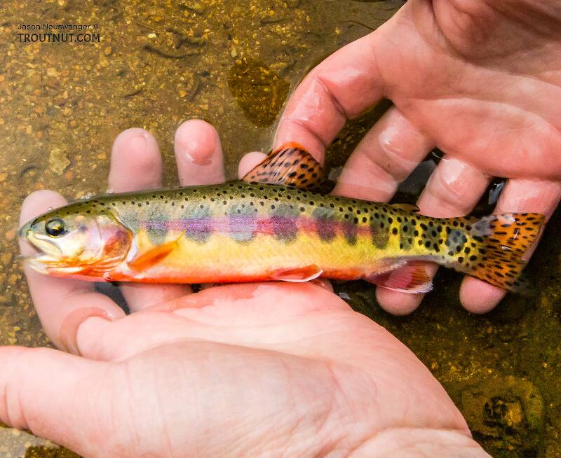
On my way past Lower Lake, I saw gold-bodied trout rising and jumping. Although it had no published history of stocking, there was a slim chance these might be Golden Trout escapees from Upper Lake, so it was worth wetting a line. They turned out to be a naturally reproducing population of Westslope Cutthroats in a variety of sizes. I caught my two biggest cutthroats yet, which isn't saying much -- these were both around 12-13 inches.


I could have enjoyed spending the day there, chasing fish that eagerly savaged any dry fly thrown in their general direction. But I hadn't climbed all this way for a type of fish I could catch in the valley bottoms. I pressed on to the route toward Upper Lake, which began with about 500 vertical feet of thick brush at an almost 40 % grade:

At one point I thought my trip was over--again--when the brushy ridge turned into cliffs above me. But I had a signal to check Google's aerial imagery on my phone, and I could see that there shouldn't be much for cliffs right there. Guessing that it must be a narrow cliff, I climbed to the side along its base until a route opened up where I could pull myself up using strong live trees. This move finally revealed an area of gently sloped alpine meadows and easy walking, with an overlook of the ridgetop I had traversed the night before:

The route to Upper Lake had one last frightening obstacle in store, a steep downclimb of a chute of vegetation between two cliffs. It's in the center of this picture:

Beyond that obstacle was a short, easy climb up picturesque slabs of rounded granite and alpine tundra to reach Upper Lake. Looking back downhill from the top of that section:

Finally, I had my first view of Upper Lake.